| Loch Ness | |
|---|---|

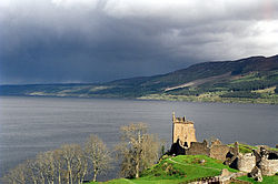
With Urquhart Castle in the foreground
|
|
| Location | Highland, Scotland |
| Coordinates | 57°18′N 4°27′WCoordinates: 57°18′N 4°27′W |
| Type | freshwater loch, oligotrophic, dimictic[1] |
| Primary inflows | River Oich/Caledonian Canal, River Moriston, River Foyers, River Enrick, River Coilte |
| Primary outflows | River Ness/Caledonian Canal |
| Catchment area | 1,770 km2 (685 sq mi) |
| Basin countries | Scotland |
| Max. length | 36.2 km (22.5 mi) |
| Max. width | 2.7 km (1.7 mi) |
| Surface area | 56 km2 (21.8 sq mi) |
| Average depth | 132 m (433 ft) |
| Max. depth | 226.96 m (744.6 ft) |
| Water volume | 7.5 km3 (1.8 cu mi) |
| Surface elevation | 15.8 m (52 ft) |
| Islands | 1 (Cherry Island) |
| Settlements | Fort Augustus, Invermoriston, Drumnadrochit, Abriachan, Lochend; Whitebridge, Foyers, Inverfarigaig, Dores. |
Location in Scotland
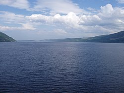
Loch Ness is the second largest Scottish loch by surface area at 22 sq mi (56 km2) after Loch Lomond, but due to its great depth, it is the largest by volume in the British Isles. Its deepest point is 755 ft (230 m),[2][3] making it the second deepest loch in Scotland after Loch Morar. A 2016 survey claimed to have discovered a crevice that pushed the depth to 889 ft (271 m) but further research determined it to be a sonar anomaly.[4] It contains more fresh water than all the lakes in England and Wales combined,[3] and is the largest body of water on the Great Glen Fault, which runs from Inverness in the north to Fort William in the south.
Contents
Villages and places
| North | ||
|---|---|---|
| Shores | Western | Eastern |
| South | ||
Urquhart Castle is located on the western shore, 1 mile (1.6 km) east of Drumnadrochit.
Lighthouses are located at Lochend (Bona Lighthouse) and Fort Augustus.
Monster
Main article: Loch Ness Monster
Loch Ness is the home of the Loch Ness Monster (also known as "Nessie"), a cryptid,
reputedly a large unknown animal. It is similar to other supposed lake
monsters in Scotland and elsewhere, though its description varies from
one account to the next. Popular interest and belief in the animal's
existence has varied since it was first brought to the world's attention
in 1933.[6]Fish species
Urquhart Bay and Loch Ness viewed from Grant's Tower at Urquhart Castle.
| European eel | Anguilla anguilla |
| Northern pike | Esox lucius |
| European sea sturgeon | Acipenser sturio (unconfirmed in the Loch, but known from Beauly–Moray Firth, which is connected via the River Ness) |
| Three-spined stickleback | Gasterosteus aculeatus |
| Brook lamprey | Lampetra planeri |
| Eurasian minnow | Phoxinus phoxinus |
| Atlantic salmon | Salmo salar |
| Sea trout | Salmo trutta |
| Brown trout (ferox trout) | Salmo trutta (Salmo ferox) |
| Arctic char | Salvelinus alpinus |
Island
The only island on Loch Ness is Cherry Island, visible at its southwestern end, near Fort Augustus. It is a crannog, which is a form of artificial island.[8] Most crannogs were constructed during the Iron Age.There was formerly a second island (Dog Island) which was submerged when the water level was raised during the construction of the Caledonian Canal.[8]


No comments:
Post a Comment